|
 Back to index Back to index
|
| Itineraries > Lucainena de las Torres Greenway |
| Lucainena de las Torres Greenway |
|

|
The old mining train between Lucainena de las Torres and Agua Amarga has provided us with one of the most authentic routes through inland Almería.
Along the foot of the Sierra de Alhamilla mountain range and following the Rambla de Lucainena, a mostly dry river course, we pass over sun-drenched terrain among farmsteads, silence, desert, solitude, mountains and ravines, grateful for any colour or vegetation we might come across.
|
| WRITE YOUR REVIEW
|
| Technical Data
|
|
 CONDITIONED GREENWAY CONDITIONED GREENWAY
|
Along the foot of the Sierra de Alhamilla mountain range following the route of the old mining railway between Lucainena de las Torres and Agua Amarga
LOCATION
Lucainena de las Torres-Puente del Saltador In Rambla Honda
ALMERÍA
Length: 5,5 km. It is possible to extend the route a further 8 km along the Rambla Honda to Polopos road (a section open to motor vehicles)
Users:  
Accessibility level:  Suitable for everyone throughout practically all the route Suitable for everyone throughout practically all the route
Type of surface:
Tarmac
|
|
 |
|
Natural setting:
Sierra Alhamilla and Rambla de Lucainena Natural Site. 12 km away is Karst en Yesos de Sorbas, a complex of gypsum caves and tunnels
Cultural Heritage:
Sierra Alhamilla and Rambla de Lucainena Natural Site. 12 km away is Karst en Yesos de Sorbas, a complex of gypsum caves and tunnels
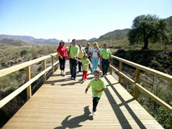
Infrastructure: Greenway, 1 Station and 5 walkways
Equipments in Infrastructure: 3 Rest areas, 1 viewpoint
Equipamientos en Estaciones: Recreation of an old station with a rest area and bicycle rental
How to get there:
By Car. If you go there by car, there are the following accesses:
Access nº 1: By the north entrance of Lucainena de las Torres, cross roads ALP-130 and ALP-721, you can park in the parking lot at the beginning of the Greenway.
GPS Coordinates (decimal format): 37.043476°, -2.202173°
Access nº 2: If you access Lucainena de las Torres by the ALP-102 highway from the southwest, after leaving the urban nucleus, by the streets of Almería or Eras, you arrive at the parking located at the beginning og the Greenway.
GPS Coordinates (digital format): 37.032247°, -2.153490°
By Bus: Empresa Alsa: Almería – Murcia line which stops at Lucainena de las Torres at the crossroads with the N-340 road
Connections:
Lucainena de las Torres is 53 km away from Almería
Greenway Manager: City Hall of Lucainena de las Torres. Tel.950 364 068.
More information in Guía de Vías Verdes (Greenways Guide) volume 3
|
|
|
|
| Description
|
|
Km. 0 / Km. 3 / Km. 5
|
Km 0
 The Lucainena Greenway sets off from the old railway station, now rehabilitated as a school. It is easy to find as it is the first building we come across as we enter the pretty town centre of Lucainena from the A-370 road. The Lucainena Greenway sets off from the old railway station, now rehabilitated as a school. It is easy to find as it is the first building we come across as we enter the pretty town centre of Lucainena from the A-370 road.
Our route begins with some panoramic views: on our left we see an expanse of arid depression; to our right the Sierra Alhamilla rises abruptly. We leave behind us the rocky crag of Lucainena towering above the town, while in front of us an adventure awaits as we descend slowly towards sea level.
The Greenway passes along the gentle foothills of the Sierra Alhamilla, dropping down towards the Rambla de Lucainena river which we cannot yet see. This area is dotted with old farmsteads and small almond orchards and, above all, olive groves. Soon we reach the first, curving, railway cutting, with some interesting brightly coloured earth embankments, providing us with an excellent geology lesson as we make our way along the Greenway.
Km 3
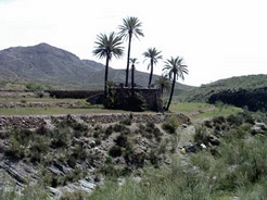
 From this point the Greenway becomes a balcony overlooking the Rambla de Lucainena river. The route becomes more interesting as we pass over a succession of gullies which drop steeply down to the river, brimming with fig trees, oleander, broom, and fruit trees. From this point the Greenway becomes a balcony overlooking the Rambla de Lucainena river. The route becomes more interesting as we pass over a succession of gullies which drop steeply down to the river, brimming with fig trees, oleander, broom, and fruit trees.
At Km 3,3 the trail takes us to Cortijo la Guitarra. A little later, as we reach a disused aqueduct, we see that the peaks of the Sierra Alhamilla have now shrunk to unimposing rounded hills.
The Greenway now sweeps around a curved embankment and passes through terraced olive groves before entering another deep and curved cutting. As we leave this cutting (Km 4.4) the hillsides are now more distant and the river is now the centre of attention. The dry river course twists and turns through gullies and ravines, trapped between high multi-hued earthen walls.
Km 5
 At El Saltador (Km 4.8) the large amount of scrub growing along the old rail bed and an impenetrable, narrow cutting which culminates in a high bridge over the Rambla de Morales river makes further progress impossible. So our Greenway makes a small detour towards a track leading to El Saltador. On this section we can see the ruins of a water mill looming above Cortijo de las Tejas. At El Saltador (Km 4.8) the large amount of scrub growing along the old rail bed and an impenetrable, narrow cutting which culminates in a high bridge over the Rambla de Morales river makes further progress impossible. So our Greenway makes a small detour towards a track leading to El Saltador. On this section we can see the ruins of a water mill looming above Cortijo de las Tejas.
The track leads us to the Rambla Honda to Polopos road (Km 5), where the Lucainena Greenway ends. However, we suggest you prolong your journey another 7 km along the road to Polopos. This is one of the most popular districts of Lucainena which grew up by the old railway line. But users should remember that this section is not yet a Greenway proper, so if we decide to press on we need to take the utmost care because we will be sharing the road with motor traffic.
If this route has left you wanting more, you will be encouraged by the fact that there is a great deal of local interest in developing the railway line from Lucainena to Aguamarga as a Greenway. So, in the not too distant future we should be able to enjoy a longer route which will take us all the way from Lucainena into the Sierra de Cabo de Gata - Níjar Natural Park.
|
|
|
|
|
|
|
|
| Railway History
|
|
La almeriense sierra Alhamilla era asiento de varias explotaciones mineras férricas. En 1893 la Compañía Minera Sierra Alhamilla comienza a explotar unos criaderos situados sobre el casco urbano de Lucainena de las Torres. A pesar de que inicialmente se había contemplado enlazar con el ferrocarril minero que bajaba desde Baños hasta Almería, la propia compañía minera abordó finalmente la construcción de su propio ferrocarril.
Éste se tendió desde la base de las minas hasta un cargadero marítimo situado a 36 km, en Agua Amarga. Las obras se concluyen en apenas dos años, y desde 1896 el ferrocarril y las minas se explotaron con una estrategia perfecta, dando unos rendimientos excelentes. Esta bonanza acaba con el final de la Primera Guerra Mundial. La crisis siderúrgica europea arrastró en su caída algunas explotaciones mineras, entre ellas ésta almeriense.
Tras la guerra civil, el ferrocarril es sometido a una intensa reforma pero, terminada ésta, se descubre que las minas estaban agotadas. Así, en el año 1942 el ferrocarril y las minas se abandonan definitivamente. En 2009 nace esta nueva vía verde que promete prolongarse para llegar hasta su destino: Agua Amarga.
|
|
|
|
|
| Links
|
|
Official Website of Turismo de Andalucía
Tourism page of the province of Almería
Official page of Lucainena de las Torres Greenway
Page of the Almería´s locality of Lucainena de las Torres
|
|
|
|
|
|
|
|
