| Guadix-Almendricos.Railway.Greenway.(Almanzora Valley Greenway) |
|

|
On the trail of an old mining railway through the Moorish valley of the River Almanzora.
This Greenway was been carried out by the Commonweath of Municipalities of Baza Region, Provincial Goverment of Andalucia, Granada County Council, Ministerio de Agricultura, Pesca y Alimentación (Nature Trails Programme) and the Town Councils of Olula el Río and Fines. More info>>
|
| WRITE YOUR REVIEW
|
| Technical data
|
|
 CONDITIONED GREENWAY CONDITIONED GREENWAY
On the trail of an old mining railway through the Moorish valley of the River Almanzora.
LOCATION
Between the El Baúl bridge in Baza (Granada) and Arboleas Almería). ANDALUCIA.
Municipalities: Baza, Caniles, Freila, Zújar, El Hijate (Granada), Alcontar, Serón, Tíjola, Purchena, Olula del Río, Fines, Cantoria, Almanzora.
Length: 98,6 km + 20 km between Huércal-Overa and Almendricos. (See here>>).
Accessibility:
 *Suitable although the pavement can sometimes have loose gravel. *Suitable although the pavement can sometimes have loose gravel.
|
|
|
 **Urban sections of Fines and Olula del Río. **Urban sections of Fines and Olula del Río.
Type of surface: compacted gravel and asphalt (urban sections of Fines and Olula del Río).
Natural setting:
Sierra de Baza Natural Park. Geopark of Granada, Sierra de los Filabres and Sierra de Lúcar, Almanzora river valley and Sierra de Enmedio.
Cultural heritage:
Baza: historic monumental complex of Baza, Baza Archaeological Museum, with important remains from the Iberian period, such as the Warrior of Baza, and a replica of the Lady of Baza, and the Alhóndiga, as well as the Basti Sites Interpretation Centre.
Zújar, Caniles y Freila: historic centres.
Fines: church of the Rosary.
Olula del Río: church of Saint Sebastian and museum Casa Ibáñez.
Purchena: remains of the citadel, museum of Islamic Archeology and church of San Ginés de la Jara.
Armudeña de Almanzora: church of the Rosary and castle ruins.
Tíjola: remains of the castles of La Cerrá II and Tíjola La Vieja. Church of Santa María and hermitage of the Virgen del Socorro.
Serón: nasrid castle, church of the Annunciation, mining town of Las Menas, Loma de los Cortijos and urban complex. Hermitages of Los Remedios, the Virgen de la Cabeza and Fuencaliente. Ramil and La Jauca watchtowers, mining archaeology, old train station and Air Interpretation Center. Planetarium and History Center
Cantoria: palace of Almanzora.
Alcóntar: church of Santiago Apostle.
Infrastructure:
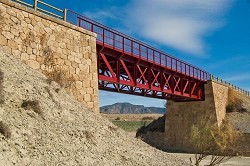
Greenway. Several metallic viaducts and bridges, highlighting those of Baúl, Canales, Baza, Valcabra and Albox. 5 tunnels. 1 walkway.
Recovered stations: Serón, Tíjola, Purchena, Almanzora, Arboleas.
Serón station: the passenger building now houses a bar-restaurant and the warehouse has been converted into the Story Station, an interesting museum dedicated to the world of stories. The Valle del Almanzora Interpretation Center, dedicated to Air, and the planetarium for astronomical observation have also been built at the station
Tíjola station: passenger building rehabilitated as a bar-restaurant, the old warehouse converted into a workshop a school and a children's playground has been set up in its surroundings.
Purchena station: passenger building houses a bar-restaurant.
Almanzora station: passenger building recovered as a bar-restaurant and picnic area.
Arboleas railway box: toruist office.
How to get there:
Car. GPS coordinates:
Start: 37.428083°, –2.931042°. Km 0 - Bridge of El Baúl.
Start: 37.404611°, –2.619549°. Provincial border Granada/ Almería.
Start: 37.358464°, –2.282855°. Km 77,70 - Fines-Olula station.
Finish: 37.353427°, –2.082470°. Km 98,60 - Arboleas crossroads.
Bus:
Bus station of Baza.
Tel. 958 702 103.
Alsa. Baza–Huércal Overa line.
Stops in El Hijate, Serón, Tíjola, Armuña de Almanzora, Purchena, Olula del Río and Fines.
Tel. 902 422 242
Connections:
Baza: 97 km to Granada.
Serón: 95 km to Almería.
Arboleas: 110 km to Almería. 129 km to Cartagena.
Managing entity of the Greenway:
Commonweath of Municipalities of Baza Region.
Tel. 958 712 208.
Commonweath of Municipalities of Valle del Almanzora.
Tel. 950 426 969.
Tourist information:
Tourism of Serón.
Tel. 675 611 002.
Connections with other routes / Greenways:
|
 |
|
|
|
|
|
|
|
|
|
|
