|
 Back to index Back to index
|
| Itineraries > Torrevieja Greenway |
|
|
|
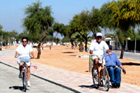
Around the Laguna Rosa (Pink Lagoon).
The Torrevieja Greenway, which could equally well be called the Salt Flats Greenway, is based on the old Albatera-Torrevieja railway line. It combines an urban section to the beach at Acequión with a nature trail around the local salt lakes.
|
| WRITE YOUR REVIEW
|
| Technical Data
|
|
 CONDITIONED GREENWAY CONDITIONED GREENWAY
|
Around the Laguna Rosa (Pink Lagoon)
LOCATION
Entre Torrevieja y la carretera de los Montesinos (CV-945)
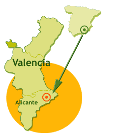
ALICANTE
Length: 6,7 km
Type of surface:
In the urban section a two-lane track, half tarmac (for cyclists) and half coloured stone set (for walkers). In the country section, compacted earth
|
|
 |
Natural setting:
La Mata and Torrevieja Lagoons Natural Park
Cultural heritage:
Interpretation Centre for the Salt Industry, Ricardo Lafuente Habanera Museum, Sea and Salt Museum, Easter Museum, Inmaculada Concepción Church, Casino, Torres Vigía (Watchtowers) and the Eras de la Sal (Salt Beds) area
Infraestructure:
Greenway
How to get there:
Public transport: Coach. Costa Azul. Alicante - Cartagena and Murcia-Torrevieja lines. Enatcar Grupo Alsa. Coaches to Torrevieja from Albacete, Barcelona, Cordoba, Madrid, Úbeda, and Seville. Bilmanbus. Santander-La Manga and Irún-La Manga
Connections:
Alicante: 52 Km from Torrevieja
Murcia: 49 Km from Torrevieja
|
|
|
|
| Description
|
|
Km. 0 / Km. 3,4 / Km. 6,7
|
The Torrevieja Greenway, based on the salt
works railway between Albatera and
Torrevieja, came about as a result of
private-public cooperation. The work was
jointly funded by the utility company
Iberdrola and the Department of the
Environment of the Generalitat Valenciana
(Valencia Regional Government), which made
it possible to remove the high tension power
line that crossed the salt lagoon at the
same time as the Greenway was being built.
In short, it was an investment in a public
service with a dual purpose.
The restored railway complex where the trail
starts comprises the old Torrevieja station
(forming part of a garden area with pine
trees, palm trees, a fountain, benches, and
a refreshment kiosk) in which the main
station building has been refurbished as a
Conference and Exhibition Centre, and three
workshops which are now home to the
Habaneras Museum, and the cargo warehouse
which has been converted into the Laguna
Rosa Interpretation Centre for the Salt
Industry.
Km 0
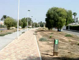 The
Greenway sets off from the left-hand side of
the interpretation centre on a trail that is
easily recognizable due to its dual surfaces;
tarmac for bikes andcoloured stone sets for
walkers. The first part of the Greenway is
flat and runs parallel to the Avenida de la
Estación, passing to the right of the old
engine sheds which are now home to an
Alzheimer’s association. Then we pass under
the N-322 ring road and are faced with a
view of the white mountains of salt,
conveyor belts, and other paraphernalia of
the salt industry. The
Greenway sets off from the left-hand side of
the interpretation centre on a trail that is
easily recognizable due to its dual surfaces;
tarmac for bikes andcoloured stone sets for
walkers. The first part of the Greenway is
flat and runs parallel to the Avenida de la
Estación, passing to the right of the old
engine sheds which are now home to an
Alzheimer’s association. Then we pass under
the N-322 ring road and are faced with a
view of the white mountains of salt,
conveyor belts, and other paraphernalia of
the salt industry.
After these views the trail enters a long
straight section lined on both sides by
terraced and detached houses with their
colourful gardens. There are a number of
level crossings where we need to take care
when crossing roads. This section has a
markedly suburban nature, the result of
Torrevieja’s expansion inland to meet the
demand for holiday homes once there was no
more room for beach front properties. The
Greenway provides the local residents with a
welcome relief from the proliferation of
traffic as Torrevieja has expanded.
Km. 3,4
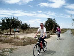 After
the sixth level crossing (Km 3.4), the last
and most dangerous one, the Greenway
undergoes some pleasant changes. The
straight lines of the trail give way to
curves, the dual cycle/pedestrian lanes
becomes a single track surfaced with
compacted earth and some gravel and, most
importantly, we leave the town behind and
enter an area of reed beds which in some
places obstruct our view of the Torrevieja
Lagoon. Reeds grow all around the edges of
the Laguna Rosa (as the Torrevieja Lagoon is
also known) and besides providing the only
touches of all year round green on this
trail, they provide a welcome refuge for a
multitude of birdlife. Black-winged stilts,
common shelducks, Montagu’s harriers,
avocets, Kentish plovers, common terns,
little terns, and stone curlews make the
Torrevieja and La Mata Lagoons places of
great ecological interest, especially given
the anthropic pressure on this part of the
coast. After
the sixth level crossing (Km 3.4), the last
and most dangerous one, the Greenway
undergoes some pleasant changes. The
straight lines of the trail give way to
curves, the dual cycle/pedestrian lanes
becomes a single track surfaced with
compacted earth and some gravel and, most
importantly, we leave the town behind and
enter an area of reed beds which in some
places obstruct our view of the Torrevieja
Lagoon. Reeds grow all around the edges of
the Laguna Rosa (as the Torrevieja Lagoon is
also known) and besides providing the only
touches of all year round green on this
trail, they provide a welcome refuge for a
multitude of birdlife. Black-winged stilts,
common shelducks, Montagu’s harriers,
avocets, Kentish plovers, common terns,
little terns, and stone curlews make the
Torrevieja and La Mata Lagoons places of
great ecological interest, especially given
the anthropic pressure on this part of the
coast.
At the end of the area of reed beds we
arrive at a rest area (Km 4.2) equipped with
benches, picnic tables, and bike stands.
Here, for the first time, we can appreciate
the calm waters and sheer size of the pink
tinted salt lagoon. Beyond the rest area (opposite
which is the International Equestrian
Centre) and a curve that could only be that
of a railway line, our Greenway straightens
out and borders the banks of the lagoon, the
perimeter of which is bounded by a chain
link fence. However, there is a pedestrian
gate at Km 5 which we can use to get to the
edge of the lagoon and walk on the white
saline surface. In such a lunar landscape
you can only wonder at the way plant life
such as glasswort, rushes, waxy saltbush,
and ragwort which abound here under
conditions of hypersalinity.
Once again on the move, at Km 5.5 we pass a
second rest area before passing between the
lagoons of Torrevieja and La Mata on a crest
known as El Chaparral, a strip of
inhospitable, uninhabited, and stony land
that defies any attempts to cultivate it.
Km. 6,7
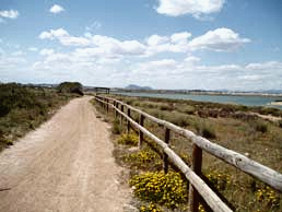 Finally
the Greenway reaches its end at the road
which leads off to the lefttowards the
village of Los Montesinos, rewarding us with
some panoramic views of the La Mata Lagoon.
About 300 metres down this road, to the
right, we can link up with the cycle lane
that runs alongside the CV-90 road to
Torrevieja or enter the La Mata Natural Park
via an entrance prohibited to motor vehicles
and climb up to one of the viewing points
overlooking the La Mata Lagoon. Or, if we
take another path that skirts around the
edge of the lagoon, we can arrive at the
Park Information Centre (some 6 km away).
The Greenway gives us the chance to make a
circular trip during which we encounter
practically no motor traffic. Finally
the Greenway reaches its end at the road
which leads off to the lefttowards the
village of Los Montesinos, rewarding us with
some panoramic views of the La Mata Lagoon.
About 300 metres down this road, to the
right, we can link up with the cycle lane
that runs alongside the CV-90 road to
Torrevieja or enter the La Mata Natural Park
via an entrance prohibited to motor vehicles
and climb up to one of the viewing points
overlooking the La Mata Lagoon. Or, if we
take another path that skirts around the
edge of the lagoon, we can arrive at the
Park Information Centre (some 6 km away).
The Greenway gives us the chance to make a
circular trip during which we encounter
practically no motor traffic.
|
|
|
|
|
|
|
|
| Railway History
|
|
If Torrevieja has an emblem it is its salt flats. This historic cornucopia of abundance was close to the route of a railway project granted to an exotically named (for these parts, at least) railway company: the Compañía de los Ferrocarriles Andaluces (CFA or Andalusia Railway Company). In 1882 this company was awarded the concession for a railway that would link the cities of Alicante and Murcia with a view to operating a future rail network that would run between Andalusia and Levante, a project that the company was never able to realize. However, in the summer of 1884 the CFA was able to open a line that initially ran parallel to the coast before gradually heading further and further inland with the idea of reaching the city of Murcia. Some 25 km from the station at Albatera were the rich salt flats of Torrevieja, an obvious destination for this railway, and to this end a spur line was built. The line was so totally dedicated to the salt industry that it never linked up with the port, but instead carried salt and agricultural products to inland markets. Its beeline route seemed to avoid towns and villages, save for the town of Torrevieja and its salt works.
Spur lines are notoriously difficult to operate profitably, and more so in the case of such a short line. So when the railways started to feel the effects of the fierce competition posed by road transport in the 60s, it was the death knell for this short line. Early in 1970 the line ceased carrying passengers and concentrated exclusively on the transport of salt. It continued to operate in this way with irregular traffic until in the late 80s one of the frequent floods of the river Segura destroyed part of the tracks. This effectively killed off the line, although it was not officially closed until early 1988. Its rails lasted a few years longer until the construction of the AP-7 motorway buried its remains and all that is left today are the sections used by our Greenway running between the La Mata and Torrevieja Lagoons and a few kilometres further inland on the way to Rojales.
|
|
|
| Interesting Data
|
|
|
|
|
|
|
|
|
|
|
|
|
1. Festivals and holidays |
|
|
|
|
|
|
|
2. Accommodation |
|
|
|
|
|
|
3. Eco-tourism |
|
|
|
|
|
|
4. Town Councils |
|
|
|
|
|
|
5. Emergencies |
|
|
|
|
|
|
6. Coaches & buses |
|
|
|
|
|
|
|
|
|
|
|
|
|
|
|
|
|
|
|
|
|
Festivals and holidays
|
 return return |
|
|
|
|
|
|
|
Torrevieja
End of June
Certamen Internacional de Habaneras y Polifonía (an international choral singing contest)
November 28
Fiestas Patronales |
|
December 17
Fiestas Patronales
Note: The term ‘fiestas’ refer to local holidays and festivals, often held in honour of the patron saint of the town or village |
|
|
|
|
|
|
|
|
|
|
|
|
Accommodation
|
 return return |
|
|
|
|
|
|
|
|
|
Hotel Fontana**
Telf. 966 701 125
www. hotelfontana .com
Hotel Central*
Telf. 965 707 750
Hotel Atlas*
Telf. 975 705 555
Hotel Cano*
Telf. 965 717 697
Camping Florantilles. 2ª categoría
Telf. 965 720 456
Camping La Campana. 2ª categoría
Telf. 965 712 152
|
|
|
|
|
|
|
|
|
|
|
|
|
Eco-tourism
|
 return return |
|
|
|
|
|
|
|
Oficina de turismo de Torrevieja. Telf. 965 705 782
Oficina de Turismo de Torrevieja Centro. Telf. 965 709 023
Oficina de Turismo Torrevieja- La Mata. Telf. 966 925 542
Rent a Bike. Telf. 965 706 391
|
|
|
|
|
|
|
|
|
|
|
|
|
Town Councils
|
 return return |
|
|
|
|
|
|
|
|
|
|
|
|
|
|
|
|
|
|
|
|
|
|
Emergencies
|
 return return |
|
|
|
|
|
|
|
EMERGENCIES: Telf. 062
|
|
|
|
|
|
|
|
|
|
|
|
|
Coaches & buses
|
 return return |
|
|
|
|
|
|
|
|
|
|
|
|
|
|
|
|
|
|
|
|
|
| Links
|
|
Portal oficial de turismo de la Comunitat Valenciana.
La Diputación de Alicante ofrece a través de esta web la información turística más completa de la provincia de Alicante: rutas, alojamientos, restaurantes y gastronomía, museos y fiestas...
Página web con todo tipo de información sobre Torrevieja y alrededores, incluye una amplia guía turística.
|
|
|
|
|
|
|
|
