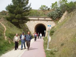
 The suggested route sets off from the railway station (now home to the local Red Cross headquarters) that used to serve Alcoi, the city of bridges, natural parks, and the popular Moors and Christians festival. Regrettably, in 2005 the route taken by the first 3 km of the old railway line through the town was used for the construction of a major three-lane road, and calls for the inclusion of a cycle lane went unheard. Our route out of Alcoi therefore takes us from the station platform, our starting point, along the railway lines towards the tunnel that we can see off to our left. On the far side of the tunnel –which at the moment is sealed off– our route takes us along a kind of track for the first few metres but soon we find ourselves on a normal urban street.
In this section through the town, some 3 km long, we pass through a further three tunnels (with lighting and pavements) and a long viaduct over the Barranco de Uxola (Uxola ravine). We need to take a little care in this section because in some tunnels we will be travelling against the flow of traffic and will need to use the pavement, so we advise cyclists to dismount in deference to pedestrians.
Km 0
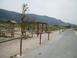 We leave Alcoi via the district of Batoi. Km 0 is situated at the Alcoi–La Canal Greenway Rest Area, which is equipped with information boards, benches, and bicycle parking facilities. Our route first takes us through a nearby beauty spot called El Salt (The Waterfall). It should be noted that, although the tunnels are equipped with lighting operated by buttons placed at intervals along the route, it might be a good idea to take a flashlight in case the lighting should fail. Soon after the Greenway proper starts, once we have left the town of Alcoi behind us, we pass through the first of the tunnels. On the other side of the tunnel we pass by a water fountain (not drinking water) which used to be some 200 metres away from the Greenway but was recently moved to a site alongside it by the Alcoi Town Council.
We soon come to the first major viaduct along the route, over the river Barchell (which features a beautiful waterfall when the water is high enough). This viaduct is dwarfed by the lofty River Polop Viaduct, spanning a tributary of the river Serpis, which we reach after passing through another tunnel, 321m long. This section of the Greenway passes through a landscape of crop fields and incipient riparian vegetation. The regular patterns of the barley and wheat fields and the olive groves along the river bank contrast with the random stands of riverside poplars.
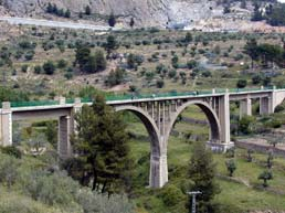 At Km 1.6 another surprise awaits us: the Siete Lunas Viaduct over the river Polop (260m long and 46m high), which provides impressive views over the town of Alcoi, and the natural parks of Font Roja and Sierra de Mariola. If we are lucky we may see some bungee jumping and, if we’re feeling adventurous... The origin of the viaduct’s lyrical name (which might be translated into English as Seven Moons Viaduct) is simple; in this region the arches of a bridge are referred to as ‘lunas’ (the normal meaning of which is ‘moons’), and the viaduct features seven concrete arches that support the railway deck. After this beautiful piece of engineering, what better than to find a convenient rest area. At Km 3.7 there is another rest area at the Mas de la Font de l’Olivereta viewing point which offers a magnificent panoramic view of the countryside and its rural architecture.
The Greenway climbs gently upwards through lush vegetation punctuated with short tunnels, not all of which are lit, until we arrive at the esplanade in front of the municipal sports centre (at Km 4.8) and its adjoining recreational area. This is a good place to take a break and get your strength back, as there is a bar/cafeteria (closed on Mondays and in August) and a rural hotel. The route thus far has been a gentle, picturesque climb of some five kilometres curving around the town of Alcoi.
Km 5
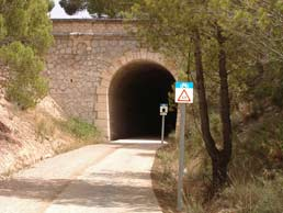 The sports center (km 5 ) starts passing through the Barranco de la Batalla (Batalla Ravine). This stretch of the Greenway passes through three of the longest tunnels on the route (two of them are 900m and 1,000m long respectively), which follow each other in quick succession. The first of the three is an amazing open-sided tunnel in which the darkness of the railway bore is magically illuminated at certain times of the day. The Greenway now runs through the Carrascal de la Font Roja Natural Park, featuring the Sant Antoni Viaduct, situated between two of the tunnels and named after the Sant Antoni mountain range in whose shadow it lies and which forms part of the Natural Park. This lofty viaduct was built to span the ravine of the same name, which converges further downstream with the Batalla Ravine and leads to the river Molinar, another tributary of the river Serpis. When the work on the motorway is finished, the Greenway will continue on as far as the Collado del Malany (the Malany Saddle). After the third long tunnel, whose exit is at Km 7.6, the Greenway passes through the high flatlands below the La Carrasqueta Pass where there is another rest area, next to the main Alcoi to Alicante road. From this point the surface is compacted earth and the landscape consists of farmland interspersed with small patches of chaparral.
Km 10
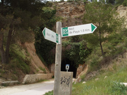 Soon we pass close to the village of La Sarga, close to which are some very interesting cave paintings. This part of the valley is known as La Canal, and we follow it until we reach a point where the old railway line passes through a private estate where we are forced to make a diversion towards the Alcoi-Alicante main road. This is a good place to conclude our trip along the Greenway, but those of you wishing to follow the old railway route a little longer can turn left at the main road and climb the Carrasqueta pass before making a right turn to get back to the railway line. Now heading towards Alcoi you go straight on at the first roundabout, ignore the turn-offs for “Alcoy” and “Alicante” and also the cycle path signposted as ”cicloruta nº 5”, before turning off onto “cicloruta nº4” and the motorway service road. You follow this cycle path for a short while and then, at the first roundabout, you follow the sign to “Alicante” which will take you back to the old railway line again. This point, where the old railway meets the road and the Greenway starts to climb the Collado del Malany, is the definitive end of the Alcoi Greenway (Km10).
